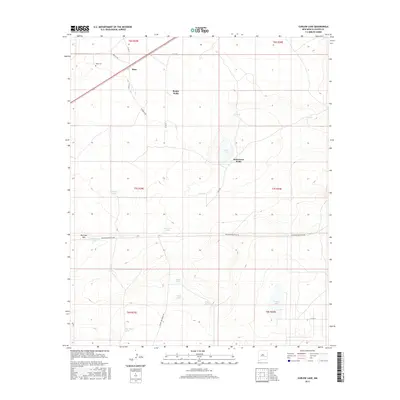
2017 Map of Curlew Lake
USGS Topo · Published 2017About this map
Boaz stands as the primary settlement in this arid pocket of Chaves County, situated near the Boaz Cem along the northern edge of the survey. The landscape is defined by its water management, or lack thereof, featuring seasonal catchments such as Salt Lake, Curlew Lake, and Road Lake. These ephemeral basins are complemented by a network of engineered water points including Beatty Wells, Robertson Wells, and numerous stock tanks like Mountain Tank and McDowell Tank. The topography is generally level, interrupted significantly only by the prominent rise of Railroad Mtn in the southwest. A grid of county roads, including Caballo Rd and White Lake Ranch Rd, facilitates movement across this ranching country, where the reliance on isolated wells and tanks suggests a way of life tethered to these critical water sources.
Find a feature on this map
32 named features on this map. Tap any name to fly to it.
Don’t see what you’re looking for? This feature index may not catch every label — zoom into the map to look around manually.
Map Details
Editions of this 2017 Curlew Lake Map
This is the sole edition of this map. No revisions or reprints were ever made.
Other maps of this area

1954 · Brownfield
USGS Topo · 1:250,000

1955 · Roswell
USGS Topo · 1:250,000

1958 · Brownfield
USGS Topo · 1:250,000

1958 · Roswell
USGS Topo · 1:250,000

1962 · Roswell
USGS Topo · 1:250,000

1962 · Brownfield
USGS Topo · 1:250,000

1967 · Elkins
USGS Topo · 1:24,000
1967 · Denton Camp
USGS Topo · 1:24,000
1967 · Sardine Lake
USGS Topo · 1:24,000

1978 · Curlew Lake
USGS Topo · 1:24,000