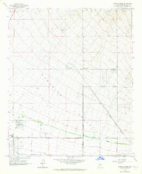
1964 Map of Currys Corner
USGS Topo · Published 1965About this map
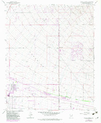
Paradise Valley serves as the broad setting for this mid-1960s desert landscape, capturing a moment of transition before the full sprawl of the suburban era. The map shows a sparse network of section-line roads such as Pima Road and Scottsdale Road crossing open terrain punctuated by the granite heights of Pinnacle Peak. Small pockets of development are visible at Currys Corner and the Ironwood Golf Course, while the Paradise Valley High Sch stands near the southern edge. A significant piece of early agricultural infrastructure, the Old Verde Canal, snakes through the valley floor, marking the historical efforts to move water through this arid environment. The presence of numerous wells and the Pinnacle Peak Substation indicates the encroaching infrastructure required for the region's coming residential growth.
Find a feature on this map
26 named features on this map. Tap any name to fly to it.
Don’t see what you’re looking for? This feature index may not catch every label — zoom into the map to look around manually.
Map Details
Editions of this 1964 Currys Corner Map
5 editions found
Other maps of this area

1904 · Camelback
USGS Topo · 1:62,500

1906 · Camelsback
USGS Topo · 1:62,500

1930 · Cave Creek
USGS Topo · 1:125,000

1939 · Cave Creek
USGS Topo · 1:125,000

1954 · Phoenix
USGS Topo · 1:250,000

1954 · Mesa
USGS Topo · 1:250,000

1957 · Mesa
USGS Topo · 1:250,000

1957 · Phoenix
USGS Topo · 1:250,000

1958 · Mesa
USGS Topo · 1:250,000

1958 · Phoenix
USGS Topo · 1:250,000