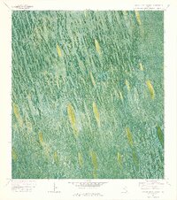
1973 Map of Custard Apple Hammock
USGS Topo · Published 1976About this map
Custard Apple Hammock defines this section of the Florida Everglades, where a vast orthophotomap reveals the intricate textures of the sawgrass and wetland landscape as it appeared in the early 1970s. The region is largely defined by the Shark Valley Slough, where water is noted as being impounded periodically. Human presence is sparse and specialized for this wet environment, marked by the Melaleuca Airboat Trail and other Airboat Trails that cut through the vegetation. A small Camp and a solitary Radio Tower provide rare fixed landmarks within the Everglades Wildlife Management Area Conservation Area No 3A. This map preserves the literal look of the terrain before later decades of environmental management and hydrological changes altered the flow of the sloughs, showing the boundary between Broward and Dade counties cutting across the wild expanse.
Find a feature on this map
9 named features on this map. Tap any name to fly to it.
Don’t see what you’re looking for? This feature index may not catch every label — zoom into the map to look around manually.
Map Details
Editions of this 1973 Custard Apple Hammock Map
2 editions found
Other maps of this area

1956 · Miami
USGS Topo · 1:250,000

1956 · West Palm Beach
USGS Topo · 1:250,000

1957 · West Palm Beach
USGS Topo · 1:250,000

1958 · West Palm Beach
USGS Topo · 1:250,000

1958 · Miami
USGS Topo · 1:250,000

1973 · Fortymile Bend
USGS Topo · 1:24,000

1973 · Custard Apple Hammock
USGS Topo · 1:24,000

1973 · West Of Pennsuco
USGS Topo · 1:24,000

1973 · Everglades 4 SE
USGS Topo · 1:24,000

1973 · Long Island
USGS Topo · 1:24,000