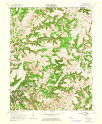
1963 Map of Custer
USGS Topo · Published 1965About this map
Marks Ridge dominates the central landscape of this 1963 Breckinridge County survey, dividing the waters of Fiddlers Creek from the deeply incised valleys to the south. The rising waters of the Rough River Reservoir are shown at their normal pool elevation of 495 feet, winding through the North Fork and Rough River channels. This era captures the rural character of the region just as large-scale hydrological changes were altering the local geography. Small settlements like Custer, Hudson, and Locust Hill serve as local hubs, connected by a network of winding roads that follow the high ground between numerous prongs and creeks. Genealogy researchers will find significant value in the high density of family burial grounds scattered throughout the hills, including Whitworth Cem, Horsley Cem, and the New Salem Ch Cem. The presence of the Lookout Tower and Alexander Chapel provides further landmarks in this traditionally agricultural landscape.
Find a feature on this map
43 named features on this map. Tap any name to fly to it.
Don’t see what you’re looking for? This feature index may not catch every label — zoom into the map to look around manually.
Map Details
Editions of this 1963 Custer Map
2 editions found
Other maps of this area

1928 · Hardinsburg
USGS Topo · 1:48,000

1931 · Hardinsburg
USGS Topo · 1:62,500

1932 · Big Clifty
USGS Topo · 1:62,500

1941 · Ekron
USGS Topo · 1:62,500

1947 · Hardinsburg
USGS Topo · 1:24,000

1947 · Garfield
USGS Topo · 1:24,000

1947 · Hardinsburg
USGS Topo · 1:62,500

1947 · Ekron
USGS Topo · 1:62,500
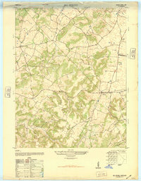
1948 · Big Spring
USGS Topo · 1:24,000

1949 · Constantine
USGS Topo · 1:24,000