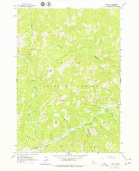
1963 Map of Custer
USGS Topo · Published 1979About this map
Mining and recreation converge in this high-elevation pocket of the Challis National Forest. The settlement of Custer serves as a focal point along the Yankee Fork, an area marked by a legacy of resource extraction as evidenced by the Sunbeam Mine, scattered prospects, and tailings. This 1960s-era survey reveals a landscape where travel was often limited to a network of trails and jeep trails connecting remote peaks and drainage basins. High summits like Estes Mtn and Mt Greylock overlook a network of creeks including Eightmile Creek and Slaughterhouse Creek. A poignant human detail is preserved at Grave BM 6528 near the river, anchoring the map's technical data to the local history of the canyon. The presence of Greylock Campground and Custer No 1 Campground indicates the early development of this region for outdoor enthusiasts.
Find a feature on this map
41 named features on this map. Tap any name to fly to it.
Don’t see what you’re looking for? This feature index may not catch every label — zoom into the map to look around manually.
Map Details
Editions of this 1963 Custer Map
2 editions found
Other maps of this area

1919 · Custer
USGS Topo · 1:125,000

1922 · Custer
USGS Topo · 1:125,000

1930 · Casto
USGS Topo · 1:125,000

1957 · Challis
USGS Topo · 1:250,000

1960 · Challis
USGS Topo · 1:250,000

1963 · Challis
USGS Topo · 1:250,000

1963 · Challis Creek Lakes
USGS Topo · 1:24,000

1963 · Custer
USGS Topo · 1:24,000

1963 · Casto
USGS Topo · 1:24,000
1963 · Elevenmile Creek
USGS Topo · 1:24,000