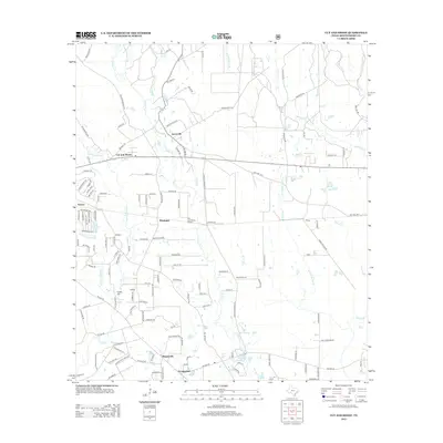
2013 Map of Cut And Shoot
USGS Topo · Published 2013About this map
Cut and Shoot and its surrounding communities are defined by a network of creeks and small drainages that feed into the San Jacinto River watershed. The area exhibits a pattern of rural residential growth, where old family settlements like Groceville, Waukegan, and Wigginsville are connected by a dense web of county roads and thoroughfares such as Crockett Martin Rd. Significant local landmarks include the Cut and Shoot Airport and Crater Hill, which overlooks the small Crater Lake. The drainage systems of Caney Cr and the W Fork Spring Br carve through the landscape, influencing the placement of settlements like Black Diamond and Timber. This 2013 survey provides a detailed record of land use in Montgomery County, illustrating how modern development has integrated with traditional Texas landscapes, from the small clusters at Grangerland to the residential areas near Lake Wildwood.
Find a feature on this map
137 named features on this map. Tap any name to fly to it.
Don’t see what you’re looking for? This feature index may not catch every label — zoom into the map to look around manually.
Map Details
Editions of this 2013 Cut And Shoot Map
This is the sole edition of this map. No revisions or reprints were ever made.
Other maps of this area

1954 · Beaumont
USGS Topo · 1:250,000

1957 · Beaumont
USGS Topo · 1:250,000

1958 · Conroe
USGS Topo · 1:24,000

1958 · Fostoria
USGS Topo · 1:24,000

1958 · Bear Creek
USGS Topo · 1:24,000

1959 · Outlaw Pond
USGS Topo · 1:24,000

1959 · Cut and Shoot
USGS Topo · 1:24,000

1959 · Conroe NE
USGS Topo · 1:24,000
1959 · Splendora
USGS Topo · 1:24,000

1960 · Willis
USGS Topo · 1:24,000