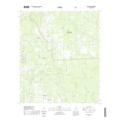
2019 Map of Cut And Shoot
USGS Topo · Published 2019About this map
Cut and Shoot and its surrounding communities are documented here in a detailed snapshot of Montgomery County's evolving landscape. The map shows a transition from the dense, managed woodlands of the Sam Houston National Forest in the northeast to the residential and rural clusters that define the southern half of the quadrangle. Settlements like Groceville, Waukegan, and Grangerland are shown along the established corridor of Old Highway 105 E, reflecting a pattern of linear development common to East Texas.
Find a feature on this map
116 named features on this map. Tap any name to fly to it.
Don’t see what you’re looking for? This feature index may not catch every label — zoom into the map to look around manually.
Map Details
Editions of this 2019 Cut And Shoot Map
This is the sole edition of this map. No revisions or reprints were ever made.
Other maps of this area

1954 · Beaumont
USGS Topo · 1:250,000

1957 · Beaumont
USGS Topo · 1:250,000

1958 · Conroe
USGS Topo · 1:24,000

1958 · Fostoria
USGS Topo · 1:24,000

1958 · Bear Creek
USGS Topo · 1:24,000

1959 · Outlaw Pond
USGS Topo · 1:24,000

1959 · Cut and Shoot
USGS Topo · 1:24,000

1959 · Conroe NE
USGS Topo · 1:24,000
1959 · Splendora
USGS Topo · 1:24,000

1960 · Willis
USGS Topo · 1:24,000