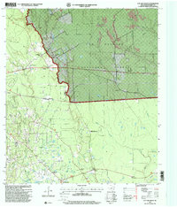
1997 Map of Cut And Shoot
USGS Topo · Published 2000About this map
The Conroe Oil Field dominates the southwestern quadrant of this 1990s topographic landscape, where industrial infrastructure like a refinery, multiple pipelines, and sludge pits intermingle with rural settlements. This portion of Montgomery County showcases a transition from the heavy extraction activity around Crater Hill to the wooded expanse of the Sam Houston National Forest. Small communities and family landmarks are scattered throughout, including Wigginsville, Grangerland, and the curiously named Cut and Shoot. Local education and faith are represented by the Austin School and the New Bethlehem Church. Waterways like Caney Creek and the West Fork San Jacinto River provide the natural drainage for a terrain increasingly marked by gravel pits and a private airstrip near Waukegan.
Find a feature on this map
37 named features on this map. Tap any name to fly to it.
Don’t see what you’re looking for? This feature index may not catch every label — zoom into the map to look around manually.
Map Details
Editions of this 1997 Cut And Shoot Map
This is the sole edition of this map. No revisions or reprints were ever made.
Other maps of this area

1954 · Beaumont
USGS Topo · 1:250,000

1957 · Beaumont
USGS Topo · 1:250,000

1958 · Conroe
USGS Topo · 1:24,000

1958 · Fostoria
USGS Topo · 1:24,000

1958 · Bear Creek
USGS Topo · 1:24,000

1959 · Outlaw Pond
USGS Topo · 1:24,000

1959 · Cut and Shoot
USGS Topo · 1:24,000

1959 · Conroe NE
USGS Topo · 1:24,000
1959 · Splendora
USGS Topo · 1:24,000

1960 · Willis
USGS Topo · 1:24,000