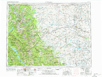
1960 Map of Cut Bank
USGS Topo · Published 1977About this map
Glacier National Park and the Blackfeet Indian Reservation dominate this Northern Montana landscape, where the Hudson Bay Divide and Continental Divide meet. The 1960s-era geography shows a transition from the high peaks of the Livingston Range to the plains of the Marias River basin. Transport through the mountains is anchored by the Going-to-the-Sun Highway and the Great Northern railroad, which skirts the park’s southern edge through East Glacier Park. On the reservation, the Blackfoot Boarding School and several isolated schoolhouses like Lone Tree School and Mountain View School reflect the mid-century social structure. To the east, the oil-and-gas fields of Cut Bank and Ethridge mark the industrial activity of the plains, while the western edge is defined by the recently formed Hungry Horse Reservoir.
Find a feature on this map
112 named features on this map. Tap any name to fly to it.
Don’t see what you’re looking for? This feature index may not catch every label — zoom into the map to look around manually.
Map Details
Editions of this 1960 Cut Bank Map
3 editions found

Other maps of this area

1886 · Great Falls
USGS Topo · 1:250,000

1901 · Browning
USGS Topo · 1:125,000

1903 · Browning
USGS Topo · 1:125,000

1903 · Saypo
USGS Topo · 1:125,000

1904 · Chief Mountain
USGS Topo · 1:125,000

1906 · Kintla Lakes
USGS Topo · 1:125,000

1907 · Blackfoot Res.
USGS Topo · 1:48,000

1909 · Cut Bank
USGS Topo · 1:125,000

1911 · Blackfoot
USGS Topo · 1:125,000

1912 · Cut Bank
USGS Topo · 1:125,000