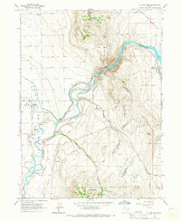
1964 Map of Cutler Dam
USGS Topo · Published 1966About this map
The Bear River carves a deep path through the Junction Hills and Long Divide on this 1964 survey, centered on the critical water infrastructure of the Cutler Dam. This landscape is defined by its complex irrigation network, featuring the West Side Canal and Hammond Main Canal that support the agricultural lands around Fielding. The Union Pacific Railroad serves the industrial and transport needs of the valley, passing through small hubs like Collinston and Cache Junction, where an Old Grade hints at earlier rail alignments. In the rugged southeast, the Wellsville Mountains and Cache National Forest provide a sharp contrast to the developed river corridor. For local historians, the map details technical aspects of the dam site, including a Powerhouse, Intake Tower, and Gaging Station, illustrating the mid-century engineering of the Bear River valley.
Find a feature on this map
34 named features on this map. Tap any name to fly to it.
Don’t see what you’re looking for? This feature index may not catch every label — zoom into the map to look around manually.
Map Details
Editions of this 1964 Cutler Dam Map
This is the sole edition of this map. No revisions or reprints were ever made.
Other maps of this area

1914 · Logan
USGS Topo · 1:125,000

1916 · Logan
USGS Topo · 1:125,000

1954 · Ogden
USGS Topo · 1:250,000

1954 · Brigham City
USGS Topo · 1:250,000

1958 · Ogden
USGS Topo · 1:250,000

1958 · Brigham City
USGS Topo · 1:250,000

1960 · Ogden
USGS Topo · 1:250,000

1961 · Honeyville
USGS Topo · 1:24,000

1961 · Tremonton
USGS Topo · 1:24,000

1962 · Brigham City
USGS Topo · 1:250,000