
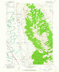
1961 Map of Honeyville
USGS Topo · Published 1963About this map
Honeyville and Deweyville sit at the western base of the Wellsville Mountains, where the steep slopes of the Cache National Forest meet the fertile Bear River valley. This 1961 survey depicts a landscape defined by water management and transit, with the Hammond Canal and the Union Pacific railroad corridor running parallel between the peaks and the meandering Bear River. The abundance of natural water sources is evident through numerous named sites such as Crystal Springs, Honeyville Springs, and Cold Spring Lakes.
Find a feature on this map
85 named features on this map. Tap any name to fly to it.
Don’t see what you’re looking for? This feature index may not catch every label — zoom into the map to look around manually.
Map Details
Editions of this 1961 Honeyville Map
2 editions found
Other maps of this area

1914 · Logan
USGS Topo · 1:125,000

1916 · Logan
USGS Topo · 1:125,000

1954 · Ogden
USGS Topo · 1:250,000

1954 · Brigham City
USGS Topo · 1:250,000

1955 · Bear River City
USGS Topo · 1:24,000

1955 · Mount Pisgah
USGS Topo · 1:24,000

1955 · Brigham City
USGS Topo · 1:24,000

1958 · Ogden
USGS Topo · 1:250,000

1958 · Brigham City
USGS Topo · 1:250,000

1960 · Ogden
USGS Topo · 1:250,000