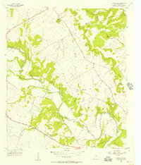
1956 Map of Cutoff Mtn
USGS Topo · Published 1957About this map
The Leon River carves a winding path through this mid-1950s landscape of Central Texas, where rural life is anchored by small country schools and cemeteries. Along the Orman Memorial Highway, the settlements of Whiteway and Evergreen show the distribution of local education and community gathering points. The topography is defined by the prominent Cutoff Mountain in the north and the deep drainage of Beck Branch and Fernash Creek. Family-named landmarks such as Viertel Cem, Bullman Cem, and Graves Cem provide essential data for genealogical research, identifying the specific locations of early area homesteads. Near the confluence of Middle Fork Neils Creek and North Fork Neils Creek, the landscape transitions from river valley bottomlands to higher ridges marked by Pleasant Valley Ch.
Find a feature on this map
23 named features on this map. Tap any name to fly to it.
Don’t see what you’re looking for? This feature index may not catch every label — zoom into the map to look around manually.
Map Details
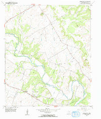
Editions of this 1956 Cutoff Mtn Map
2 editions found
Other maps of this area

1888 · Hamilton
USGS Topo · 1:125,000

1888 · Meridian
USGS Topo · 1:125,000

1894 · Hamilton
USGS Topo · 1:125,000

1894 · Meridian
USGS Topo · 1:125,000

1954 · Brownwood
USGS Topo · 1:250,000

1954 · Waco
USGS Topo · 1:250,000

1955 · Waco
USGS Topo · 1:250,000
1955 · Ater
USGS Topo · 1:24,000
1956 · Jonesboro
USGS Topo · 1:24,000

1956 · Cranfills Gap
USGS Topo · 1:24,000