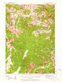
1942 Map of Cutoff Mtn
USGS Topo · Published 1963About this map
Independence Mine sits near the headwaters of the Boulder River, marking a point of industrial interest within the high-elevation terrain of the Absaroka National Forest during the early 1940s. The landscape is defined by the headwaters of major drainages, including the Stillwater River and the meandering Slough Creek, which flows south into Yellowstone National Park. This area serves as a critical transition between protected forest lands and the northern reaches of the national park, where the Slough Creek Guard Sta and Silver Tip Ranch represent the few points of human habitation.
Find a feature on this map
71 named features on this map. Tap any name to fly to it.
Don’t see what you’re looking for? This feature index may not catch every label — zoom into the map to look around manually.
Map Details
Editions of this 1942 Cutoff Mtn Map
4 editions found

Other maps of this area

1886 · Canyon
USGS Topo · 1:125,000

1891 · Livingston
USGS Topo · 1:250,000

1893 · Livingston
USGS Topo · 1:250,000

1895 · Canyon
USGS Topo · 1:125,000

1896 · Canyon
USGS Topo · 1:125,000

1896 · Crandall Creek
USGS Topo · 1:125,000

1898 · Granite Mountain District
USGS Topo · 1:125,000

1899 · Crandall
USGS Topo · 1:125,000

1901 · Canyon
USGS Topo · 1:125,000

1907 · Canyon
USGS Topo · 1:125,000