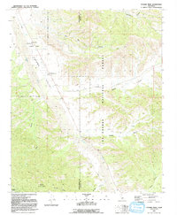
1991 Map of Cuyama Peak
USGS Topo · Published 1991About this map
Ventucopa sits at the heart of the Cuyama Valley, serving as a central point of human activity within the surrounding expanse of the Los Padres National Forest. This 1991 survey illustrates the complex relationship between the low-lying agricultural and ranching potential of the Cuyama River basin and the steep, drainage-scarred topography of the Santa Barbara and Ventura county line. The landscape is defined by its dramatic verticality, rising from the valley floor to the high point of Cuyama Peak Lookout and the protected lands of the Dick Smith Wilderness.
Find a feature on this map
20 named features on this map. Tap any name to fly to it.
Don’t see what you’re looking for? This feature index may not catch every label — zoom into the map to look around manually.
Map Details
Editions of this 1991 Cuyama Peak Map
2 editions found
Other maps of this area

1902 · Santa Ynez
USGS Topo · 1:125,000

1903 · Mt. Pinos
USGS Topo · 1:125,000

1905 · Santa Ynez
USGS Topo · 1:125,000

1942 · Ballinger Canyon
USGS Topo · 1:24,000

1942 · East of Cuyama Ranch
USGS Topo · 1:24,000

1943 · Rancho Nuevo Creek
USGS Topo · 1:24,000

1943 · Apache Canyon
USGS Topo · 1:24,000

1943 · Santiago Creek
USGS Topo · 1:24,000
1943 · Ballinger Canyon
USGS Topo · 1:24,000

1943 · Cuyama Peak
USGS Topo · 1:24,000