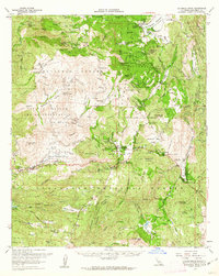
1960 Map of Cuyamaca Peak
USGS Topo · Published 1962About this map
Cuyamaca Peak and its surrounding highlands anchor this mid-century survey of the San Diego backcountry. The landscape is defined by the significant tracts of the Cuyamaca Rancho State Park and Cleveland National Forest, providing a detailed look at the recreational and tribal lands of the era. The Cuyamaca Reservoir is a prominent feature in the north, while the historical Stonewall Mine sits nearby, marking the region's earlier industrial activity.
Find a feature on this map
102 named features on this map. Tap any name to fly to it.
Don’t see what you’re looking for? This feature index may not catch every label — zoom into the map to look around manually.
Map Details
Editions of this 1960 Cuyamaca Peak Map
2 editions found
Other maps of this area

1893 · El Cajon
USGS Topo · 1:62,500

1901 · Elcajon
USGS Topo · 1:62,500

1903 · Cuyamaca
USGS Topo · 1:125,000

1903 · Elcajon
USGS Topo · 1:62,500

1903 · Ramona
USGS Topo · 1:125,000

1904 · Southern California Sheet No. 2
USGS Topo · 1:250,000

1931 · Vallecito
USGS Topo · 1:125,000

1931 · Carrizo
USGS Topo · 1:125,000

1939 · El Cajon
USGS Topo · 1:62,500

1939 · Campo
USGS Topo · 1:62,500