
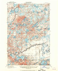
1913 Map of Cuyuna
USGS Topo · Published 1963About this map
The Mississippi River winds through the southern reaches of this 1913 survey, defining a landscape of complex drainage and nascent industrial settlement in the Cuyuna Range. The village of Cuyuna sits at the nexus of the Minneapolis St Paul and Sault Ste Marie and Northern Pacific railroads, reflecting the critical role of rail transport in this mining and timber region. To the north, the settlement of Emily is surrounded by a dense network of glacial lakes including Ruth Lake, Lake Emily, and Little Pine Lake.
Find a feature on this map
77 named features on this map. Tap any name to fly to it.
Don’t see what you’re looking for? This feature index may not catch every label — zoom into the map to look around manually.
Map Details
Editions of this 1913 Cuyuna Map
2 editions found
Other maps of this area

1912 · Deerwood
USGS Topo · 1:62,500

1914 · Deerwood
USGS Topo · 1:62,500

1914 · Aitkin
USGS Topo · 1:62,500

1915 · Aitkin
USGS Topo · 1:62,500

1915 · Cuyuna
USGS Topo · 1:62,500

1915 · Brainerd
USGS Topo · 1:62,500

1916 · Wealthwood
USGS Topo · 1:62,500

1918 · Brainerd
USGS Topo · 1:62,500

1953 · Duluth
USGS Topo · 1:250,000

1953 · Brainerd
USGS Topo · 1:250,000