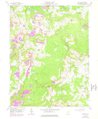
1959 Map of Cuzzart
USGS Topo · Published 1977About this map
Cuzzart and the surrounding high country of Pleasant Mountains are defined by a complex network of headwater streams and active industrial sites in this late 1950s survey. The landscape is marked by extensive strip mines that weave through the ridges between Muddy Creek and Beaver Creek. Human settlement is centered on small community hubs like Centenary and Lenox, each anchored by local institutions such as Centenary Ch and Wesley Ch.
Find a feature on this map
46 named features on this map. Tap any name to fly to it.
Don’t see what you’re looking for? This feature index may not catch every label — zoom into the map to look around manually.
Map Details
Editions of this 1959 Cuzzart Map
4 editions found
Other maps of this area

1886 · St. George
USGS Topo · 1:125,000

1891 · St. George
USGS Topo · 1:125,000

1895 · Piedmont
USGS Topo · 1:125,000

1899 · Oakland
USGS Topo · 1:62,500

1900 · Accident
USGS Topo · 1:62,500

1900 · Oakland
USGS Topo · 1:62,500

1904 · Bruceton
USGS Topo · 1:62,500

1907 · Kingwood
USGS Topo · 1:62,500

1925 · Kingwood
USGS Topo · 1:62,500

1926 · Bruceton
USGS Topo · 1:62,500