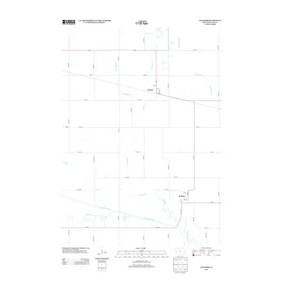
2013 Map of Cylinder
USGS Topo · Published 2013About this map
Cylinder and Rodman serve as the primary hubs in this agricultural landscape of Palo Alto County. The terrain is defined by a sophisticated system of water management, visible through numerous artificial waterways like Ditch Number 80, Ditch Number 61, and the aptly named Dry Ditch. These engineered channels cut across the prairie to manage the watershed surrounding Cylinder Creek and the meandering Des Moines River. In the southern portion of the map, the complex hydrology of the river valley is highlighted by the Old Channel, indicating how the natural course has shifted over time. The geometric grid of rural roads, including English Rd and numbered avenues like 510th Ave, reflects the systematic land division that has governed North Central Iowa for generations.
Find a feature on this map
37 named features on this map. Tap any name to fly to it.
Don’t see what you’re looking for? This feature index may not catch every label — zoom into the map to look around manually.
Map Details
Editions of this 2013 Cylinder Map
This is the sole edition of this map. No revisions or reprints were ever made.
Other maps of this area

1954 · Fairmont
USGS Topo · 1:250,000

1954 · Fort Dodge
USGS Topo · 1:250,000

1957 · Fort Dodge
USGS Topo · 1:250,000

1958 · Fort Dodge
USGS Topo · 1:250,000

1958 · Fairmont
USGS Topo · 1:250,000

1980 · Fenton
USGS Topo · 1:24,000

1980 · Depew
USGS Topo · 1:24,000
1980 · Mallard
USGS Topo · 1:24,000

1980 · Plover
USGS Topo · 1:24,000

1980 · Graettinger East
USGS Topo · 1:24,000