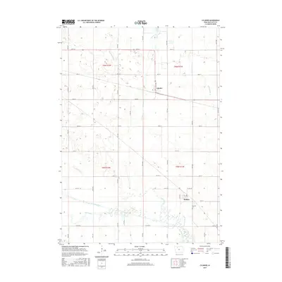
2015 Map of Cylinder
USGS Topo · Published 2015About this map
The Des Moines River winds through the southern portion of this Palo Alto County landscape, where the Old Channel reveals the shifting hydrology of the Iowa prairie. This modern survey illustrates the highly managed drainage network of the region, featuring engineered waterways such as Ditch Number 80, Dry Ditch, and Number Sixtyone. The small community of Cylinder is established along the highway at the north, while Rodman sits further south near the riverbanks. Local history is anchored at Riverside Cem, located just north of the river bend. The map provides a detailed view of the section-line road grid that defines the agricultural townships of t96n r32w, t96n r31w, and their neighbors, demonstrating the enduring influence of the Public Land Survey System on the modern Iowa countryside.
Find a feature on this map
27 named features on this map. Tap any name to fly to it.
Don’t see what you’re looking for? This feature index may not catch every label — zoom into the map to look around manually.
Map Details
Editions of this 2015 Cylinder Map
This is the sole edition of this map. No revisions or reprints were ever made.
Other maps of this area

1954 · Fairmont
USGS Topo · 1:250,000

1954 · Fort Dodge
USGS Topo · 1:250,000

1957 · Fort Dodge
USGS Topo · 1:250,000

1958 · Fort Dodge
USGS Topo · 1:250,000

1958 · Fairmont
USGS Topo · 1:250,000

1980 · Fenton
USGS Topo · 1:24,000

1980 · Depew
USGS Topo · 1:24,000
1980 · Mallard
USGS Topo · 1:24,000

1980 · Plover
USGS Topo · 1:24,000

1980 · Graettinger East
USGS Topo · 1:24,000