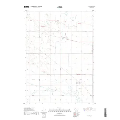
2018 Map of Cylinder
USGS Topo · Published 2018About this map
Cylinder and Rodman anchor this agricultural landscape in Palo Alto County, where the topography is defined by the winding course of the Des Moines River and its accompanying Old Channel. The map illustrates a region heavily shaped by water management and drainage, notably through features like Ditch Number 80 and Dry Ditch, which support the intensive grid of section-line roads. This network of thoroughfares, including 400th St and 510th Ave, connects the scattered farmsteads of the Iowa plains.
Find a feature on this map
37 named features on this map. Tap any name to fly to it.
Don’t see what you’re looking for? This feature index may not catch every label — zoom into the map to look around manually.
Map Details
Editions of this 2018 Cylinder Map
This is the sole edition of this map. No revisions or reprints were ever made.
Other maps of this area

1954 · Fairmont
USGS Topo · 1:250,000

1954 · Fort Dodge
USGS Topo · 1:250,000

1957 · Fort Dodge
USGS Topo · 1:250,000

1958 · Fort Dodge
USGS Topo · 1:250,000

1958 · Fairmont
USGS Topo · 1:250,000

1980 · Fenton
USGS Topo · 1:24,000

1980 · Depew
USGS Topo · 1:24,000
1980 · Mallard
USGS Topo · 1:24,000

1980 · Plover
USGS Topo · 1:24,000

1980 · Graettinger East
USGS Topo · 1:24,000