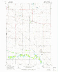
1980 Map of Cylinder
USGS Topo · Published 1981About this map
The town of Cylinder serves as a central hub on this 1980s landscape, situated at the junction of the Chicago Milwaukee St Paul And Pacific railroad and Cylinder Creek. The map documents a highly organized agricultural and drainage system, characterized by numerous ditches like Ditch No 80 and Ditch No 61 that segment the townships of Freedom, Fairfield, and Nevada. To the south, the village of Rodman sits near the Chicago Rock Island And Pacific line and the Riverside Cem. The most striking geographical feature is the Old Channel Des Moines River, where the original meandering path of the water is clearly visible alongside active Gravel Pits, illustrating the historical shift of the riverbed and the area's reliance on glacial deposits for local industry.
Find a feature on this map
20 named features on this map. Tap any name to fly to it.
Don’t see what you’re looking for? This feature index may not catch every label — zoom into the map to look around manually.
Map Details
Editions of this 1980 Cylinder Map
This is the sole edition of this map. No revisions or reprints were ever made.
Other maps of this area

1954 · Fairmont
USGS Topo · 1:250,000

1954 · Fort Dodge
USGS Topo · 1:250,000

1957 · Fort Dodge
USGS Topo · 1:250,000

1958 · Fort Dodge
USGS Topo · 1:250,000

1958 · Fairmont
USGS Topo · 1:250,000

1980 · Fenton
USGS Topo · 1:24,000

1980 · Depew
USGS Topo · 1:24,000
1980 · Mallard
USGS Topo · 1:24,000

1980 · Plover
USGS Topo · 1:24,000

1980 · Graettinger East
USGS Topo · 1:24,000