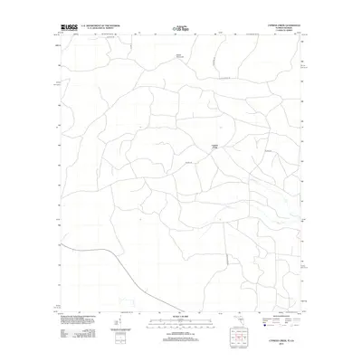
2012 Map of Cypress Creek
USGS Topo · Published 2012About this map
Cypress Creek and its surrounding wetlands define the rural character of this Hamilton County landscape as it appeared in the early 21st century. The map reveals a dense network of timber roads and fire breaks, such as Flaline Break Rd, cutting through the managed forests and low-lying hammocks typical of this border region. Martin Hammock stands as a prominent natural landmark in the northern reaches of the quadrangle, while the drainage of Cypress Cr and Rocky Cr dictates the local topography. This period of the landscape is marked by a mix of agricultural access and forestry infrastructure, with named routes like Fales Steel Rd and Stewart Rd providing the primary transit arteries through the pine-dominated terrain.
Find a feature on this map
11 named features on this map. Tap any name to fly to it.
Don’t see what you’re looking for? This feature index may not catch every label — zoom into the map to look around manually.
Map Details
Editions of this 2012 Cypress Creek Map
This is the sole edition of this map. No revisions or reprints were ever made.
Other maps of this area

1954 · Valdosta
USGS Topo · 1:250,000

1955 · Jasper
USGS Topo · 1:24,000

1955 · Cypress Creek
USGS Topo · 1:24,000

1955 · Fargo SW
USGS Topo · 1:24,000

1958 · Valdosta
USGS Topo · 1:250,000

1959 · Valdosta
USGS Topo · 1:250,000

1961 · Hillcoat
USGS Topo · 1:24,000

1962 · Genoa
USGS Topo · 1:24,000

1968 · Needmore
USGS Topo · 1:24,000
1969 · Benton
USGS Topo · 1:24,000