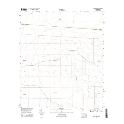
2015 Map of Cypress Creek
USGS Topo · Published 2015About this map
Martin Hammock and the low-lying wetlands of the Florida-Georgia border define this 2015 survey of Hamilton and Echols counties. The landscape is characterized by the meandering courses of Cypress Cr and Rocky Cr, which drain southward through a network of rural routes and logging roads. The small settlement of Cypress Creek serves as a central point in an area dominated by timber and agricultural land use, crisscrossed by specialized infrastructure like Flaline Break Rd and Stewart Rd. This map captures the modern layout of the Public Land Survey System grids, showing the intricate boundary where Hamilton Co, Florida, meets Echols Co, Georgia. The distribution of local names such as Christie Tower Rd and Glassy Bay Rd reflects the continued importance of family and landmark-based navigation in this borderland region.
Find a feature on this map
20 named features on this map. Tap any name to fly to it.
Don’t see what you’re looking for? This feature index may not catch every label — zoom into the map to look around manually.
Map Details
Editions of this 2015 Cypress Creek Map
This is the sole edition of this map. No revisions or reprints were ever made.
Other maps of this area

1954 · Valdosta
USGS Topo · 1:250,000

1955 · Jasper
USGS Topo · 1:24,000

1955 · Cypress Creek
USGS Topo · 1:24,000

1955 · Fargo SW
USGS Topo · 1:24,000

1958 · Valdosta
USGS Topo · 1:250,000

1959 · Valdosta
USGS Topo · 1:250,000

1961 · Hillcoat
USGS Topo · 1:24,000

1962 · Genoa
USGS Topo · 1:24,000

1968 · Needmore
USGS Topo · 1:24,000
1969 · Benton
USGS Topo · 1:24,000