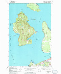
1973 Map of Cypress Island
USGS Topo · Published 1994About this map
Cypress Island and Guemes Island dominate this coastal landscape in Skagit County, where the maritime geography of the San Juan archipelago meets the mainland at Anacortes. The 1973 survey, updated with 1994 revisions, illustrates a transition from the industrial and transportation hub of the south to the more isolated island terrain to the north. On Guemes Island, the community is anchored by Indian Village and the Eden Cem, with the West Shore Road tracing the coastline.
Find a feature on this map
52 named features on this map. Tap any name to fly to it.
Don’t see what you’re looking for? This feature index may not catch every label — zoom into the map to look around manually.
Map Details
Editions of this 1973 Cypress Island Map
2 editions found
Other maps of this area

1943 · Richardson
USGS Topo · 1:62,500

1943 · Orcas Island
USGS Topo · 1:62,500

1943 · Deception Pass
USGS Topo · 1:62,500

1943 · Anacortes
USGS Topo · 1:62,500

1951 · Deception Pass
USGS Topo · 1:62,500

1951 · Anacortes
USGS Topo · 1:62,500

1957 · Richardson
USGS Topo · 1:62,500

1957 · Orcas Island
USGS Topo · 1:62,500

1957 · Victoria
USGS Topo · 1:250,000

1973 · Cypress Island
USGS Topo · 1:24,000