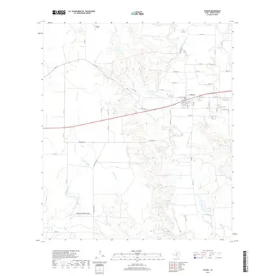
2019 Map of D'Hanis
USGS Topo · Published 2019About this map
D'Hanis serves as the central hub of this Medina County landscape, situated where the historic Old Hwy 90 meets the modern highway corridor. The town's grid is small but detailed, featuring streets like Main St and Buena Vista St. The area's ancestral history is well-documented through several burial sites, including Rothe Cem, Saint Dominic Cem, Cortez Cem, and Holy Cross Cem, many of which are tucked along the winding drainages of Seco Cr and Parkers Cr.
Find a feature on this map
57 named features on this map. Tap any name to fly to it.
Don’t see what you’re looking for? This feature index may not catch every label — zoom into the map to look around manually.
Map Details
Editions of this 2019 D'Hanis Map
This is the sole edition of this map. No revisions or reprints were ever made.
Other maps of this area

1928 · Frio Town
USGS Topo · 1:62,500

1954 · San Antonio
USGS Topo · 1:250,000

1956 · Sabinal
USGS Topo · 1:62,500

1956 · New Fountain
USGS Topo · 1:62,500

1957 · San Antonio
USGS Topo · 1:250,000

1964 · Yancey
USGS Topo · 1:24,000

1969 · Sabinal NE
USGS Topo · 1:24,000

1969 · Comanche Waterhole
USGS Topo · 1:24,000
1969 · Mustang Valley
USGS Topo · 1:24,000
1970 · Irishman Hill
USGS Topo · 1:24,000