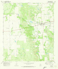
1970 Map of D'hanis
USGS Topo · Published 1973About this map
D'Hanis sits as a vital rail and industrial hub in Medina County during the early 1970s, defined by its position along the Southern Pacific railroad. The town's economic foundations are visible through the presence of nearby Kilns and multiple Gravel Pits, indicating a landscape shaped by resource extraction and processing. This survey offers significant genealogical value through its cluster of family and parish burial grounds, including the Rothe Cem, Cortez Cem, and the St Dominic Cem near the town center, along with the Holy Cross Cem to the south.
Find a feature on this map
23 named features on this map. Tap any name to fly to it.
Don’t see what you’re looking for? This feature index may not catch every label — zoom into the map to look around manually.
Map Details
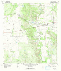
Editions of this 1970 D'hanis Map
2 editions found
Other maps of this area

1928 · Frio Town
USGS Topo · 1:62,500

1954 · San Antonio
USGS Topo · 1:250,000

1956 · Sabinal
USGS Topo · 1:62,500

1956 · New Fountain
USGS Topo · 1:62,500

1957 · San Antonio
USGS Topo · 1:250,000

1964 · Yancey
USGS Topo · 1:24,000

1969 · Sabinal NE
USGS Topo · 1:24,000

1969 · Comanche Waterhole
USGS Topo · 1:24,000
1969 · Mustang Valley
USGS Topo · 1:24,000
1970 · Irishman Hill
USGS Topo · 1:24,000