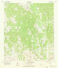
1962 Map of Dacus
USGS Topo · Published 1975About this map
The settlement of Dacus sits at the intersection of rural transit and timberland, where the Sam Houston National Forest meets the rolling agricultural lands of eastern Texas. During the early 1960s, this area served as a crossroads for several major rail lines, including the Fort Worth and Denver (C B & Q) and the Chicago Rock Island and Pacific. These tracks bisect the landscape, cutting through a dense network of watercourses like Little Caney Creek and Lake Creek.
Find a feature on this map
27 named features on this map. Tap any name to fly to it.
Don’t see what you’re looking for? This feature index may not catch every label — zoom into the map to look around manually.
Map Details
Editions of this 1962 Dacus Map
2 editions found
Other maps of this area

1954 · Beaumont
USGS Topo · 1:250,000

1957 · Beaumont
USGS Topo · 1:250,000

1959 · San Jacinto
USGS Topo · 1:24,000

1959 · Montgomery
USGS Topo · 1:24,000

1961 · Anderson
USGS Topo · 1:24,000

1961 · Stoneham
USGS Topo · 1:24,000

1962 · Keenan
USGS Topo · 1:24,000

1962 · Dacus
USGS Topo · 1:24,000

1962 · Plantersville
USGS Topo · 1:24,000

1962 · Richards
USGS Topo · 1:24,000