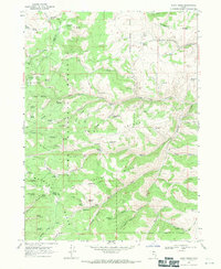
1968 Map of Dairy Ridge
USGS Topo · Published 1971About this map
Cache National Forest dominates this high-altitude landscape in northern Utah, where the tri-county corner of Rich, Weber, and Cache counties meets. This 1968 field-checked survey reveals a rugged geography defined by prominent mountain structures including Dairy Ridge, Wasatch Ridge, and Baldy Ridge. The area's water management and livestock history are visible through the Dairy Ridge Reservoir and numerous named springs like Bountiful Spring and Neponset Spring that feed the various forks and hollows.
Find a feature on this map
72 named features on this map. Tap any name to fly to it.
Don’t see what you’re looking for? This feature index may not catch every label — zoom into the map to look around manually.
Map Details
Editions of this 1968 Dairy Ridge Map
3 editions found
Other maps of this area

1912 · Randolph
USGS Topo · 1:125,000

1914 · Logan
USGS Topo · 1:125,000

1916 · Logan
USGS Topo · 1:125,000

1954 · Ogden
USGS Topo · 1:250,000

1958 · Ogden
USGS Topo · 1:250,000

1960 · Ogden
USGS Topo · 1:250,000

1964 · Monte Cristo PK
USGS Topo · 1:24,000
1964 · Causey Dam
USGS Topo · 1:24,000

1968 · Horse Ridge
USGS Topo · 1:24,000

1968 · Dairy Ridge
USGS Topo · 1:24,000