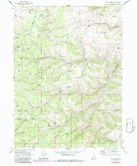
1968 Map of Dairy Ridge
USGS Topo · Published 1986About this map
Dairy Ridge forms the high-elevation backbone of this landscape at the intersection of the Cache National Forest and Wasatch National Forest. The 1968 field survey reveals a terrain defined by high peaks and an intricate network of named water sources essential for forest management and local ranching. Notable summits like Eccles Peak and Baldy Peak rise above a series of prominent formations including Wasatch Ridge and Strawberry Ridge. Evidence of mid-century infrastructure is found at the Monte Cristo Guard Sta and the nearby Monte Cristo Campground, indicating the area's role in forest administration and recreation. The mapping of numerous springs, such as Neponset Spring and Davenport Spring, alongside the Dairy Ridge Reservoir, highlights the critical importance of water management in these high Utah highlands. Traces of historical activity appear in names like Sawmill Canyon and a localized Gravel Pit, while the Prospect Road suggests early exploration through the hollows.
Find a feature on this map
73 named features on this map. Tap any name to fly to it.
Don’t see what you’re looking for? This feature index may not catch every label — zoom into the map to look around manually.
Map Details
Editions of this 1968 Dairy Ridge Map
3 editions found
Other maps of this area

1912 · Randolph
USGS Topo · 1:125,000

1914 · Logan
USGS Topo · 1:125,000

1916 · Logan
USGS Topo · 1:125,000

1954 · Ogden
USGS Topo · 1:250,000

1958 · Ogden
USGS Topo · 1:250,000

1960 · Ogden
USGS Topo · 1:250,000

1964 · Monte Cristo PK
USGS Topo · 1:24,000
1964 · Causey Dam
USGS Topo · 1:24,000

1968 · Horse Ridge
USGS Topo · 1:24,000

1968 · Dairy Ridge
USGS Topo · 1:24,000