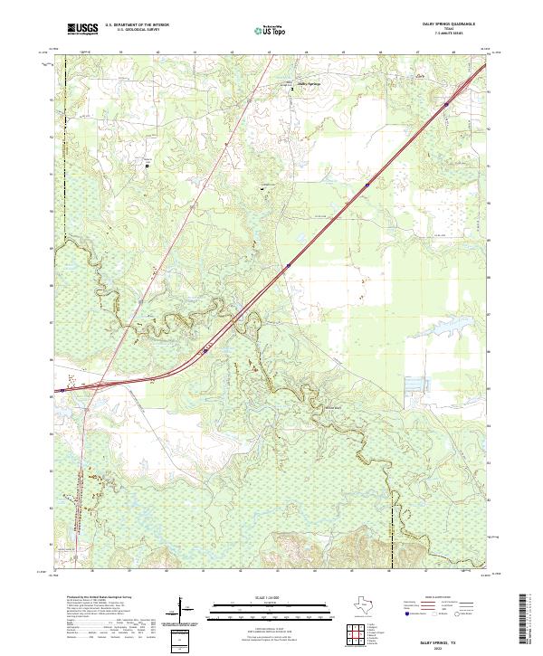
2022 Map of Dalby Springs
USGS Topo · Published 2022About this map
Dalby Springs serves as the focal point of this region in the 2020s, situated near the confluence of several prominent watercourses and family-named landmarks. The landscape is defined by the winding course of the Sulphur River and White Oak Creek, which create a complex network of wetlands and sloughs including Molly Clark Slough. These waterways are flanked by numerous named lakes such as Greenhaw Lake, Shaw Lake, and the evocatively named Black Cat Lake, suggesting a terrain historically shaped by seasonal flooding and shifting river channels. Genealogists will find significant value in the documentation of several local burial grounds, including Dalby Springs Cem, Roberts Cem, and Lumpkin Cem, which provide anchors for family history research in this corner of Bowie County near the Morris and Cass county lines.
Find a feature on this map
47 named features on this map. Tap any name to fly to it.
Don’t see what you’re looking for? This feature index may not catch every label — zoom into the map to look around manually.
Map Details
Editions of this 2022 Dalby Springs Map
This is the sole edition of this map. No revisions or reprints were ever made.
Other maps of this area

1914 · Daingerfield
USGS Topo · 1:62,500

1930 · Bassett
USGS Topo · 1:62,500

1953 · Texarkana
USGS Topo · 1:250,000

1956 · Texarkana
USGS Topo · 1:250,000

1965 · Lydia
USGS Topo · 1:24,000
1965 · Hodgson
USGS Topo · 1:24,000

1965 · Marietta
USGS Topo · 1:24,000
1965 · Malta
USGS Topo · 1:24,000

1965 · Dalby Springs
USGS Topo · 1:24,000
1965 · Bassett
USGS Topo · 1:24,000