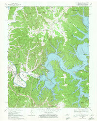
1968 Map of Dale Hollow Dam
USGS Topo · Published 1971About this map
The Obey River defines this landscape on the border of Tennessee and Kentucky, where the massive Dale Hollow Dam creates the expansive Dale Hollow Reservoir. This survey highlights a transitional moment for the region as the Cordell Hull Reservoir was being established, with blue hatching indicating areas of upcoming submergence along the river bends near Celina. The terrain is characterized by steep ridges like Pea Ridge and Swann Ridge, which dictated the early settlement patterns and the placement of remote outposts such as Thompsons Store and Ashlock. Genealogists will find a wealth of family-named landmarks and small burial grounds including the Tinsley Cem, Walker Cem, and Buford Cem. Cultural life is marked by local landmarks like Cave Springs Ch and the Dale Hollow Fish Hatchery, situated just downstream from the dam's power infrastructure.
Find a feature on this map
76 named features on this map. Tap any name to fly to it.
Don’t see what you’re looking for? This feature index may not catch every label — zoom into the map to look around manually.
Map Details
Editions of this 1968 Dale Hollow Dam Map
3 editions found
Other maps of this area

1897 · Standingstone
USGS Topo · 1:125,000

1898 · Standingstone
USGS Topo · 1:125,000

1924 · Lillydale
USGS Topo · 1:62,500

1925 · Gainesboro
USGS Topo · 1:62,500

1926 · Lillydale
USGS Topo · 1:62,500

1929 · Lillydale
USGS Topo · 1:62,500

1929 · Gainesboro
USGS Topo · 1:62,500

1929 · Tompkinsville
USGS Topo · 1:62,500

1944 · Livingston
USGS Topo · 1:24,000

1954 · Frogue
USGS Topo · 1:24,000