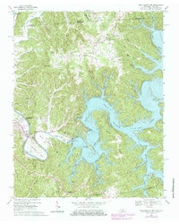
1968 Map of Dale Hollow Dam
USGS Topo · Published 1979About this map
The Obey River and the massive impoundment of Dale Hollow Lake dominate this landscape along the Tennessee and Kentucky border. This study, field checked in the late 1960s with purple revisions from the mid-1970s, captures the region's infrastructure centered on the Dale Hollow Dam and the adjacent Dale Hollow Fish Hatchery. The town of Celina sits at the western edge of the map, where the river winds through deep bends like Walker Bend and Peterman Bend. Away from the water, the terrain rises sharply into ridges such as Peak Ridge and Swann Ridge, marked by high points like Pilot Knob. Local commerce and community life are represented by Thompsons Store and rural congregations at Rock Springs Ch and Cave Springs Ch, while numerous family cemeteries like Donaldson Cem and Key Cem dot the hollows.
Find a feature on this map
85 named features on this map. Tap any name to fly to it.
Don’t see what you’re looking for? This feature index may not catch every label — zoom into the map to look around manually.
Map Details
Editions of this 1968 Dale Hollow Dam Map
3 editions found
Other maps of this area

1897 · Standingstone
USGS Topo · 1:125,000

1898 · Standingstone
USGS Topo · 1:125,000

1924 · Lillydale
USGS Topo · 1:62,500

1925 · Gainesboro
USGS Topo · 1:62,500

1926 · Lillydale
USGS Topo · 1:62,500

1929 · Lillydale
USGS Topo · 1:62,500

1929 · Gainesboro
USGS Topo · 1:62,500

1929 · Tompkinsville
USGS Topo · 1:62,500

1944 · Livingston
USGS Topo · 1:24,000

1954 · Frogue
USGS Topo · 1:24,000