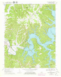
1968 Map of Dale Hollow Dam
USGS Topo · Published 1979About this map
Dale Hollow Dam controls the flow of the Obey River in this Tennessee-Kentucky borderland survey, which documents the complex shoreline and rising waters of Dale Hollow Lake and the Cordell Hull Reservoir. The landscape is a network of winding hollows and ridges, where family-named landmarks like Walker Bend and Peterman Bend sit alongside essential local infrastructure like the Dale Hollow Fish Hatchery.
Find a feature on this map
91 named features on this map. Tap any name to fly to it.
Don’t see what you’re looking for? This feature index may not catch every label — zoom into the map to look around manually.
Map Details
Editions of this 1968 Dale Hollow Dam Map
3 editions found
Other maps of this area

1897 · Standingstone
USGS Topo · 1:125,000

1898 · Standingstone
USGS Topo · 1:125,000

1924 · Lillydale
USGS Topo · 1:62,500

1925 · Gainesboro
USGS Topo · 1:62,500

1926 · Lillydale
USGS Topo · 1:62,500

1929 · Lillydale
USGS Topo · 1:62,500

1929 · Gainesboro
USGS Topo · 1:62,500

1929 · Tompkinsville
USGS Topo · 1:62,500

1944 · Livingston
USGS Topo · 1:24,000

1954 · Frogue
USGS Topo · 1:24,000