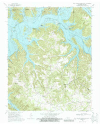
1968 Map of Dale Hollow Reservoir SE
USGS Topo · Published 1987About this map
The Dale Hollow Reservoir dominates the landscape, where the inundated valleys of the Obey River and Wolf River meet along the state line. This survey, field-checked in 1968, illustrates the complex topography of the Highland Rim, characterized by deep hollows like Tipton Hollow and high points such as Chowning Knob. The settlement pattern reflects the transition from river-bottom farming to a reservoir-based economy, with the Willow Grove Recreation Area and Lillydale Recreation Area marking new land uses.
Find a feature on this map
57 named features on this map. Tap any name to fly to it.
Don’t see what you’re looking for? This feature index may not catch every label — zoom into the map to look around manually.
Map Details
Editions of this 1968 Dale Hollow Reservoir SE Map
2 editions found
Other maps of this area

1897 · Standingstone
USGS Topo · 1:125,000

1898 · Standingstone
USGS Topo · 1:125,000

1924 · Lillydale
USGS Topo · 1:62,500

1926 · Lillydale
USGS Topo · 1:62,500

1929 · Lillydale
USGS Topo · 1:62,500

1929 · Byrdstown
USGS Topo · 1:62,500

1944 · Livingston
USGS Topo · 1:24,000

1954 · Frogue
USGS Topo · 1:24,000

1954 · Blacks Ferry
USGS Topo · 1:24,000

1954 · Albany
USGS Topo · 1:24,000