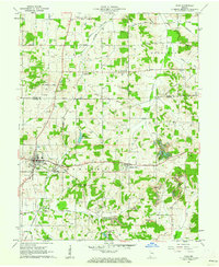
1961 Map of Dale
USGS Topo · Published 1963About this map
Dale serves as the primary hub for this portion of southern Indiana, where the Southern railroad line facilitates local transport and commerce. The landscape is defined by a mix of agricultural clearings and industrial activity, notably the numerous Strip Mine excavations scattered throughout the southern half of the quadrangle. A historic Indian Treaty Boundary cuts diagonally across the terrain, serving as a lasting marker of early nineteenth-century land division. Smaller communities like St Henry, Johnsburg, and Mariah Hill provide local focal points, each anchored by traditional landmarks such as St Josephs Ch. Genealogists will find a wealth of data in the well-distributed burial grounds, including Mt Zion Cem, Mt Vernon Cem, and Pinkston Cem. Water resources are managed via the Dale Reservoir and the winding course of Little Pigeon Creek, while the presence of the Huntingburg Airport in the north suggests the region's mid-century modernization.
Find a feature on this map
33 named features on this map. Tap any name to fly to it.
Don’t see what you’re looking for? This feature index may not catch every label — zoom into the map to look around manually.
Map Details
Editions of this 1961 Dale Map
2 editions found
Other maps of this area

1900 · St Meinrad
USGS Topo · 1:62,500

1900 · De Gonia Springs
USGS Topo · 1:62,500

1902 · Ditney
USGS Topo · 1:125,000

1902 · Degonia Springs
USGS Topo · 1:62,500

1903 · St. Meinrad
USGS Topo · 1:62,500

1903 · Velpen
USGS Topo · 1:62,500

1954 · Huntingburg
USGS Topo · 1:24,000

1955 · Saint Anthony
USGS Topo · 1:24,000

1956 · Vincennes
USGS Topo · 1:250,000

1957 · Vincennes
USGS Topo · 1:250,000