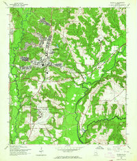
1960 Map of Daleville
USGS Topo · Published 1964About this map
Fort Rucker and the adjacent town of Daleville dominate this 1960 landscape, reflecting the intensive military aviation expansion in Southeast Alabama during the mid-century. The Fort Rucker Military Reservation is meticulously detailed with its operational infrastructure, including Lowe Airfield, Hanchey Heliport, and various Landing Strips. This concentration of military facilities contrasts with the traditional rural character of the surrounding area, where small settlements like Kelly and Five Points sit near the winding Choctawhatchee River.
Find a feature on this map
33 named features on this map. Tap any name to fly to it.
Don’t see what you’re looking for? This feature index may not catch every label — zoom into the map to look around manually.
Map Details
Editions of this 1960 Daleville Map
Other maps of this area

1942 · Enterprise
USGS Topo · 1:125,000

1948 · Ozark
USGS Topo · 1:62,500

1950 · Ozark
USGS Topo · 1:62,500

1950 · Enterprise
USGS Topo · 1:62,500

1953 · Dothan
USGS Topo · 1:250,000

1954 · Dothan
USGS Topo · 1:250,000

1955 · Dothan
USGS Topo · 1:250,000

1957 · Malvern
USGS Topo · 1:24,000

1957 · Geneva
USGS Topo · 1:62,500

1957 · Hartford
USGS Topo · 1:62,500