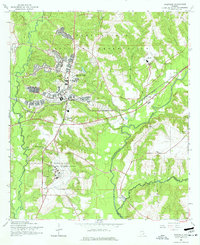
1960 Map of Daleville
USGS Topo · Published 1977About this map
The Fort Rucker Military Reservation dominates this 1960 landscape, illustrating the significant mid-century military infrastructure in Dale County. The map details the complex layout of Fort Rucker, including specialized aviation facilities like Hanchey Heliport, Lowe Airfield, and various Landing Strips. Adjacent to the base, the town of Daleville serves as a civilian hub along the Atlantic Coast Line railroad.
Find a feature on this map
33 named features on this map. Tap any name to fly to it.
Don’t see what you’re looking for? This feature index may not catch every label — zoom into the map to look around manually.
Map Details
Editions of this 1960 Daleville Map
Other maps of this area

1942 · Enterprise
USGS Topo · 1:125,000

1948 · Ozark
USGS Topo · 1:62,500

1950 · Ozark
USGS Topo · 1:62,500

1950 · Enterprise
USGS Topo · 1:62,500

1953 · Dothan
USGS Topo · 1:250,000

1954 · Dothan
USGS Topo · 1:250,000

1955 · Dothan
USGS Topo · 1:250,000

1957 · Malvern
USGS Topo · 1:24,000

1957 · Geneva
USGS Topo · 1:62,500

1957 · Hartford
USGS Topo · 1:62,500