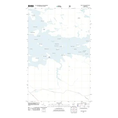
2011 Map of Daley Bay
USGS Topo · Published 2011About this map
Kabetogama Lake dominates this northern Minnesota landscape, where a dense archipelago of islands creates a complex network of waterways and points. The terrain is characterized by these landforms, including names like Nashata Point, Sugarbush Island, and the ironically named Donut Island. In the northern reach, the Shoepack Lookout Tower stands near the shores of Shoepack Lake and Little Shoepack Lake, serving as a vital landmark for forest surveillance in this heavily wooded region. The Ash River winds through the northern and central sections before meeting the larger lake, while the Ash River Trl provides one of the few terrestrial access points in the south. This mapping reveals a landscape shaped by water and wilderness, where local geography is defined by rocky outcrops like Capie Rock and the many channels surrounding Martin Island and Richie Island.
Find a feature on this map
37 named features on this map. Tap any name to fly to it.
Don’t see what you’re looking for? This feature index may not catch every label — zoom into the map to look around manually.
Map Details
Editions of this 2011 Daley Bay Map
This is the sole edition of this map. No revisions or reprints were ever made.
Other maps of this area

1954 · International Falls
USGS Topo · 1:250,000

1957 · International Falls
USGS Topo · 1:250,000

1958 · International Falls
USGS Topo · 1:250,000

1967 · Kempton Bay
USGS Topo · 1:24,000

1968 · Soldier Point
USGS Topo · 1:24,000

1968 · Daley Bay
USGS Topo · 1:24,000

1968 · Ash River SE
USGS Topo · 1:24,000

1968 · Ash River NE
USGS Topo · 1:24,000

1968 · Ash River SW
USGS Topo · 1:24,000

1969 · Ray SE
USGS Topo · 1:24,000