Loading...
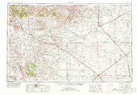
Loading map...1954 Map of Dalhart
USGS Topo · Published 1978About this map
Boise City and Dalhart anchor this high plains junction, a mid-century view of the Tri-State area where Texas, New Mexico, and Oklahoma meet. The landscape is defined by volcanic features like Sierra Grande and the iconic cinder cone of Capulin Mountain National Monument. These landmarks rise above a grid of cattle ranches and windmills, with the Cimarron River and North Canadian River carving drainage patterns across the arid terrain.
Find a feature on this map
101 named features on this map. Tap any name to fly to it.
Don’t see what you’re looking for? This feature index may not catch every label — zoom into the map to look around manually.
Map Details
Date Portrayed1954
Date Published1978
PublisherU.S. Geological Survey
Map TypeTopographic
Scale1:250,000
Physical Dimensions31.9 x 22.1 inches
Editions of this 1954 Dalhart Map
2 editions found

Historical Maps of Dalhart Through Time

Featured Locations
Source Details
SourceU.S. Geological Survey
CopyrightPublic Domain