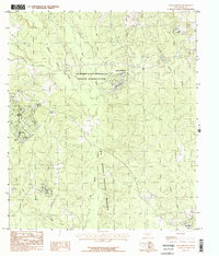
1984 Map of Dallardsville
USGS Topo · Published 1984About this map
The Alabama and Coushatta Indian Reservation and the sprawling Big Thicket National Preserve define this section of East Texas, where the landscape is intricately carved by numerous tributaries of Big Sandy Creek. The settlement of Indian Village sits near the headwaters of Lake Tombigbee, while further south, Dallardsville marks the southeastern corner of this densely wooded terrain.
Find a feature on this map
23 named features on this map. Tap any name to fly to it.
Don’t see what you’re looking for? This feature index may not catch every label — zoom into the map to look around manually.
Map Details
Editions of this 1984 Dallardsville Map
This is the sole edition of this map. No revisions or reprints were ever made.
Other maps of this area

1954 · Beaumont
USGS Topo · 1:250,000

1955 · Camden
USGS Topo · 1:62,500

1955 · New Willard
USGS Topo · 1:62,500

1957 · Beaumont
USGS Topo · 1:250,000

1958 · Livingston
USGS Topo · 1:62,500

1958 · Segno
USGS Topo · 1:62,500

1984 · Segno
USGS Topo · 1:24,000

1984 · Hortense
USGS Topo · 1:24,000

1984 · Soda
USGS Topo · 1:24,000

1984 · Beaumont
USGS Topo · 1:250,000