
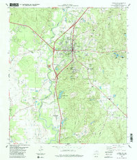
1984 Map of Soda
USGS Topo · Published 1984About this map
Soda and the surrounding piney woods of Polk County are defined by a complex network of waterways and industrial infrastructure in the mid-1970s. The landscape is carved by numerous drainages, most notably Menard Creek and Beech Creek, which feed into larger systems beyond the quadrangle. Local heritage is preserved in several family or community burial grounds, including Nettles Cem, Turner Cem, and Bluff Creek Cem, while Oak Grove Ch serves as a local landmark near the central settlement.
Find a feature on this map
24 named features on this map. Tap any name to fly to it.
Don’t see what you’re looking for? This feature index may not catch every label — zoom into the map to look around manually.
Map Details
Editions of this 1984 Soda Map
This is the sole edition of this map. No revisions or reprints were ever made.
Other maps of this area

1954 · Beaumont
USGS Topo · 1:250,000

1955 · Camden
USGS Topo · 1:62,500

1955 · New Willard
USGS Topo · 1:62,500

1957 · Beaumont
USGS Topo · 1:250,000

1958 · Livingston
USGS Topo · 1:62,500

1958 · Segno
USGS Topo · 1:62,500

1984 · Segno
USGS Topo · 1:24,000

1984 · Hortense
USGS Topo · 1:24,000

1984 · Beaumont
USGS Topo · 1:250,000
1984 · Livingston
USGS Topo · 1:24,000