
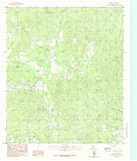
1984 Map of Hortense
USGS Topo · Published 1984About this map
The timbered hills and deep creek valleys of eastern Polk County define this landscape during the early 1980s. The small settlement of Hortense sits at a junction of rural routes, surrounded by a dense network of watercourses including Smith Creek, Coonlop Creek, and Bear Creek. To the east, the boundary with Tyler County follows the ridge lines between drainage basins like Caney Creek and Woods Creek. This provisional survey preserves the rural character of the Big Thicket region before modern expansion, showing isolated structures and logging roads that serviced the local pine economy. Numerous spring-fed tributaries, such as Massey Spring Branch and Mountain Branch, suggest a terrain historically shaped by seasonal water flow and timber harvesting. Other scattered locations like Kennedy and the headwaters of Mill Creek provide specific points of interest for those tracing the development of these back-country Texas communities.
Find a feature on this map
18 named features on this map. Tap any name to fly to it.
Don’t see what you’re looking for? This feature index may not catch every label — zoom into the map to look around manually.
Map Details
Editions of this 1984 Hortense Map
This is the sole edition of this map. No revisions or reprints were ever made.
Other maps of this area

1954 · Beaumont
USGS Topo · 1:250,000

1955 · Camden
USGS Topo · 1:62,500

1955 · New Willard
USGS Topo · 1:62,500

1957 · Beaumont
USGS Topo · 1:250,000

1958 · Livingston
USGS Topo · 1:62,500

1958 · Segno
USGS Topo · 1:62,500
1984 · Chester
USGS Topo · 1:24,000

1984 · Soda
USGS Topo · 1:24,000

1984 · Beaumont
USGS Topo · 1:250,000

1984 · Jacks Creek North
USGS Topo · 1:24,000