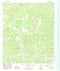
1984 Map of Chester
USGS Topo · Published 1984About this map
Chester serves as the primary hub of this East Texas landscape, positioned within a complex network of waterways that define the local topography. This 1984 survey highlights the settlement at Peach Tree Village and the prominent rising terrain of Big Hill to the north. The area is characterized by a dense drainage system, where Russell Creek and Otter Creek intersect with smaller tributaries such as Hardy Branch and Wolf Branch. This hydrographic pattern suggests a rural economy tied closely to the land and timber, with transportation routes following the natural contours between creek beds. A scattered Cem (cemetery) location and various unnamed structures point to the long-standing community presence in this part of Tyler County. The map also traces the winding courses of Caney Creek and Cowpen Creek, providing a detailed look at the drainage basins that feed into the larger regional river systems.
Find a feature on this map
20 named features on this map. Tap any name to fly to it.
Don’t see what you’re looking for? This feature index may not catch every label — zoom into the map to look around manually.
Map Details
Editions of this 1984 Chester Map
This is the sole edition of this map. No revisions or reprints were ever made.
Other maps of this area

1927 · Lufkin 4-c
USGS Topo · 1:24,000

1928 · Zavalla 3-c
USGS Topo · 1:24,000

1928 · Lufkin 4-d
USGS Topo · 1:24,000

1931 · Zavalla
USGS Topo · 1:62,500

1932 · Manning
USGS Topo · 1:62,500

1953 · Palestine
USGS Topo · 1:250,000

1954 · Beaumont
USGS Topo · 1:250,000

1955 · Woodville
USGS Topo · 1:62,500

1955 · Camden
USGS Topo · 1:62,500

1957 · Beaumont
USGS Topo · 1:250,000