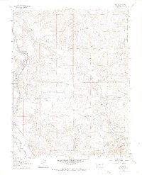
1963 Map of Dallas
USGS Topo · Published 1971About this map
The Uncompahgre River corridor serves as the primary artery for travel and industry in this portion of Colorado, anchored by the settlement of Dallas. This early 1960s survey documents a landscape where traditional water management through systems like Alkali Ditch NO 1 and Sneva Ditch NO 1 sustains the valley floors. Transportation history is deeply layered here, featuring the active Denver and Rio Grande Western Railroad alongside an Old Railroad Grade, indicating shifting routes through the river canyon. Beyond the valley, the terrain rises sharply into the Uncompahgre National Forest, reaching landmarks such as Courthouse Mountain and Ramshorn Ridge. For those interested in local social history, the presence of the Orvis Hot Spring and the County Fairground highlights the area's role as a regional gathering point.
Find a feature on this map
40 named features on this map. Tap any name to fly to it.
Don’t see what you’re looking for? This feature index may not catch every label — zoom into the map to look around manually.
Map Details
Editions of this 1963 Dallas Map
4 editions found
Other maps of this area

1902 · Ouray
USGS Topo · 1:62,500

1904 · Ouray
USGS Topo · 1:62,500

1909 · Montrose
USGS Topo · 1:125,000

1911 · Montrose
USGS Topo · 1:125,000

1955 · Ouray
USGS Topo · 1:24,000

1956 · Montrose
USGS Topo · 1:250,000

1959 · Montrose
USGS Topo · 1:250,000

1960 · Montrose
USGS Topo · 1:250,000
1963 · Buckhorn Lakes
USGS Topo · 1:24,000
1963 · Courthouse Mountain
USGS Topo · 1:24,000