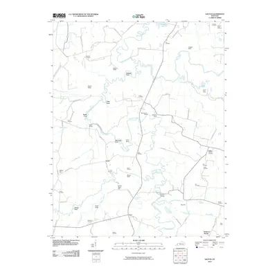
2010 Map of Dalton
USGS Topo · Published 2010About this map
The Tradewater River winds through this landscape, defining the boundaries and connections of rural Hopkins County. This 2010 survey highlights a history tied to the land, where numerous river crossings like Utley Ford, Smith Ford, and Baldwin Ford once facilitated movement between agricultural and mining communities. The terrain is marked by prominent bluffs and ridges, such as Morse Bluff and Hickory Ridge, which overlook the complex network of creeks including Donaldson Creek and Lick Creek.
Find a feature on this map
86 named features on this map. Tap any name to fly to it.
Don’t see what you’re looking for? This feature index may not catch every label — zoom into the map to look around manually.
Map Details
Editions of this 2010 Dalton Map
This is the sole edition of this map. No revisions or reprints were ever made.
Other maps of this area

1907 · Earlington
USGS Topo · 1:48,000

1908 · Princeton
USGS Topo · 1:62,500

1909 · Dawson Springs
USGS Topo · 1:48,000

1909 · Earlington
USGS Topo · 1:62,500

1909 · Providence
USGS Topo · 1:62,500

1910 · Princeton
USGS Topo · 1:62,500

1911 · Dawson Springs
USGS Topo · 1:62,500

1954 · Evansville
USGS Topo · 1:250,000
1954 · Nebo
USGS Topo · 1:24,000
1954 · Shady Grove
USGS Topo · 1:24,000