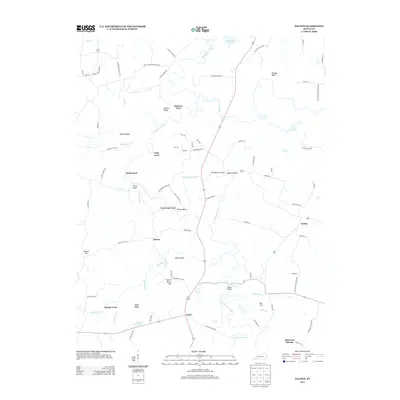
2013 Map of Dalton
USGS Topo · Published 2013About this map
The Tradewater River defines the landscape of this Hopkins County region, winding through a series of significant river crossings and topographic landmarks. Named fords such as Baldwin Ford, Utley Ford, Smith Ford, and Tom Gray Ford indicate a long history of local movement across the waterway, connecting rural communities like Dalton and Kirkwood Springs. The terrain is marked by distinct elevations and river features, including Dunbar Bluff, Morse Bluff, and the prominent curve at Tayloe Bend. Local water sources like Lowey Gum Spring and Willimson Spring further characterize the area's hydrology. This 2013 survey documents the persistent rural character of the region, where family-named roads and small settlements like Quinn and Fryer are situated among the ridges and creek valleys of the Kentucky countryside.
Find a feature on this map
87 named features on this map. Tap any name to fly to it.
Don’t see what you’re looking for? This feature index may not catch every label — zoom into the map to look around manually.
Map Details
Editions of this 2013 Dalton Map
This is the sole edition of this map. No revisions or reprints were ever made.
Other maps of this area

1907 · Earlington
USGS Topo · 1:48,000

1908 · Princeton
USGS Topo · 1:62,500

1909 · Dawson Springs
USGS Topo · 1:48,000

1909 · Earlington
USGS Topo · 1:62,500

1909 · Providence
USGS Topo · 1:62,500

1910 · Princeton
USGS Topo · 1:62,500

1911 · Dawson Springs
USGS Topo · 1:62,500

1954 · Evansville
USGS Topo · 1:250,000
1954 · Nebo
USGS Topo · 1:24,000
1954 · Shady Grove
USGS Topo · 1:24,000