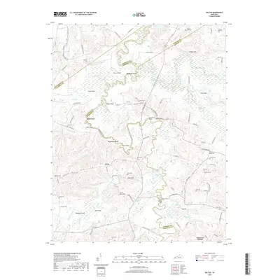
2019 Map of Dalton
USGS Topo · Published 2019About this map
The Tradewater River winds through this rural landscape at the intersection of Caldwell, Hopkins, and Webster Counties. This river-valley terrain is defined by a series of historic river crossings, including Baldwin Ford, Utley Ford, and Smith Ford, alongside early infrastructure like Towery Bridge. The map serves as a vital resource for genealogists, documenting a high density of family and community burial grounds such as Holloman Cem, Bell Cem, and the Pleasant Valley Cem.
Find a feature on this map
98 named features on this map. Tap any name to fly to it.
Don’t see what you’re looking for? This feature index may not catch every label — zoom into the map to look around manually.
Map Details
Editions of this 2019 Dalton Map
This is the sole edition of this map. No revisions or reprints were ever made.
Other maps of this area

1907 · Earlington
USGS Topo · 1:48,000

1908 · Princeton
USGS Topo · 1:62,500

1909 · Dawson Springs
USGS Topo · 1:48,000

1909 · Earlington
USGS Topo · 1:62,500

1909 · Providence
USGS Topo · 1:62,500

1910 · Princeton
USGS Topo · 1:62,500

1911 · Dawson Springs
USGS Topo · 1:62,500

1954 · Evansville
USGS Topo · 1:250,000
1954 · Nebo
USGS Topo · 1:24,000
1954 · Shady Grove
USGS Topo · 1:24,000