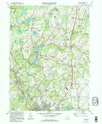
1994 Map of Dalton
USGS Topo · Published 1995About this map
Lackawanna State Park anchors this central Pennsylvania landscape, dominated by the waters of Lackawanna Lake and the winding course of the South Branch Tunkhannock Creek. The terrain is defined by numerous family-named summits such as Lee Hill, Sarnoski Hill, and Carpenter Hill, which separate the small settlements and crossroads of Fleetville, Waverly, and Clarks Green. Aviation history is present at the Endless Mountains Airport, while local genealogy is well-documented through a high density of small burial grounds including the Decker Cem, Sicklers Cem, and Hickory Grove Cem.
Find a feature on this map
86 named features on this map. Tap any name to fly to it.
Don’t see what you’re looking for? This feature index may not catch every label — zoom into the map to look around manually.
Map Details
Editions of this 1994 Dalton Map
This is the sole edition of this map. No revisions or reprints were ever made.
Other maps of this area

1889 · Scranton
USGS Topo · 1:62,500

1891 · Scranton
USGS Topo · 1:62,500

1892 · Dundaff
USGS Topo · 1:62,500

1893 · Pittston
USGS Topo · 1:62,500

1893 · Scranton
USGS Topo · 1:62,500

1943 · Scranton
USGS Topo · 1:125,000

1946 · Tunkhannock
USGS Topo · 1:62,500

1946 · Dalton
USGS Topo · 1:24,000

1946 · Olyphant
USGS Topo · 1:24,000

1946 · Ransom
USGS Topo · 1:24,000
Featured Places
- Scott Township, PA
- Glenburn Township, PA
- Dalton, PA
- La Plume Township, PA
- Carpenter Town, Benton Township