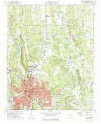
1972 Map of Dalton North
USGS Topo · Published 1984About this map
Dalton serves as the industrial and urban heart of this region, shown here during a period of significant mid-century expansion. The city's residential and civic growth is evidenced by numerous institutions like City Park Sch, Fort Hill Sch, and the Armory, while the local economy is tied to the Southern railroad line running north through Waring. To the west, the prominent ridge of Hamilton Mountain overlooks Haig Mill Lake, providing a sharp topographic contrast to the developed valley floors.
Find a feature on this map
74 named features on this map. Tap any name to fly to it.
Don’t see what you’re looking for? This feature index may not catch every label — zoom into the map to look around manually.
Map Details
Editions of this 1972 Dalton North Map
Other maps of this area

1886 · Dalton
USGS Topo · 1:125,000

1886 · Ringgold
USGS Topo · 1:125,000

1892 · Ringgold
USGS Topo · 1:125,000

1892 · Dalton
USGS Topo · 1:125,000

1897 · Dalton
USGS Topo · 1:125,000
1935 · Tiger Creek
USGS Topo · 1:24,000

1935 · Villanow
USGS Topo · 1:24,000

1935 · Ringgold
USGS Topo · 1:24,000

1935 · Tunnel Hill
USGS Topo · 1:24,000

1938 · Chatsworth
USGS Topo · 1:48,000