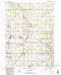
1994 Map of Damascus
USGS Topo · Published 1997About this map
Damascus sits at the junction of four townships along the Mahoning Co Columbiana Co line, serving as a central hub for a landscape defined by traditional Ohio agriculture and small crossroads settlements. This 1994 photoinspection reveals a network of rural communities including Beloit, Garfield, and Snodes, connected by historic corridors like the Western Reserve Road and Calla Road. The northern edge is dominated by the waters of Berlin Lake and its associated State Wildlife Area, while the 3 Tracks railroad line cuts a straight path through the township of Goshen. The map details local social anchors, from the West Branch High Sch and Camp Merrydale to quiet landmarks like Wilbur Ch and the secluded Seva-keen Lake. Traces of the Connecticut Western Reserve surveying tradition are visible in the alignment of roads and land boundaries across the county line.
Find a feature on this map
53 named features on this map. Tap any name to fly to it.
Don’t see what you’re looking for? This feature index may not catch every label — zoom into the map to look around manually.
Map Details
Editions of this 1994 Damascus Map
This is the sole edition of this map. No revisions or reprints were ever made.
Other maps of this area

1906 · Ravenna
USGS Topo · 1:62,500

1908 · Warren
USGS Topo · 1:62,500

1908 · Ravenna
USGS Topo · 1:62,500

1909 · Alliance
USGS Topo · 1:62,500

1909 · Lisbon
USGS Topo · 1:62,500

1950 · Cleveland
USGS Topo · 1:250,000

1951 · Canton
USGS Topo · 1:250,000

1952 · Lake Milton
USGS Topo · 1:24,000

1952 · Canfield
USGS Topo · 1:24,000

1952 · Alliance
USGS Topo · 1:24,000